DJI Matrice 400
DJI Matrice 400, the enterprise flagship drone platform, boasts an impressive 59-minute flight time, a payload capacity of up to 6 kg, and integrated rotating LiDAR and mmWave radar for power-line-level obstacle sensing. It also supports the O4 Enterprise Enhanced Video Transmission and Airborne Relay Video Transmission, ensuring safer handling and easier operations. Combining Smart Detection with visible and thermal imaging, AR projection, ship-based takeoff/landing, and advanced automation, Matrice 400 excels in emergency response, power inspections, mapping, and AEC.
Buy NowReal-Time Terrain Follow
Matrice 400 supports Real-Time Terrain Follow flight in any horizontal direction. This feature can be enabled during both manual flight and automated flight routes, ensuring stable relative height to the ground.
Takeoff and Landing on Ships
To address the needs of offshore operations such as maritime patrol and wind turbine inspection, Matrice 400 is equipped with the capability to take off from and land on ships, supporting takeoff from stationary vessels and landing on moving vessels. By detecting landing point patterns on the deck, it can achieve safe and precise landings.
Aircraft Fusion Positioning
The omnidirectional sensing performance brought by rotating LiDAR, high-precision mmWave radar, and full-color low-light fisheye vision sensors provides Matrice 400 with strong positioning capabilities. It can fly stably close to glass-facade buildings or wind turbine blades and safely return from building edges, mountain bases, or bridge sides even when the return point has not been updated.
Live Annotations
Without modeling, you can mark points on the remote controller screen to obtain subject locations, draw lines to measure distances between multiple points, and outline areas to calculate their size. Measurement results can be synchronized to the DJI FlightHub 2 to enhance team efficiency.
Map View AR
When operating during the day or night in urban regions, the remote controller can display the names of buildings and landmarks in real-time, marking core roads with prominent lines.
Power Line Follow With Zenmuse L3
During tasks such as power grid inspection, the obstacle sensing system automatically detects frontal wire obstacles and displays easily recognizable AR lines on the remote controller’s screen, making the surrounding environment clear at a glance and ensuring safer flight.
Multi-Payload, Multi-Scene
Matrice 400’s strong payload capacity allows it to easily meet the demands of a wide range of applications. With a maximum payload capacity of 6 kg, Matrice 400 supports seamless switching between a single downward gimbal and a dual downward gimbal. It also features a third gimbal connector on the underside for additional flexibility. The aircraft is equipped with 4 external E-Port V2 ports, enabling simultaneous mounting of up to 7 payloads.

Flight Time
Estimate the Matrice 400’s flight time based on payload configuration.

Powerful Payloads
Depending on the task, Matrice 400 can be equipped with the Zenmuse H30 Series, L2, P1, S1 Spotlight, V1 Speaker, Manifold 3, or third-party payloads, thereby expanding its capabilities and unlocking the full potential of the DJI ecosystem.


Software Designed for Industries
DJI FlightHub 2
Specifically for the Matrice 400, DJI FlightHub 2 has been upgraded to enable cloud-based remote control, allowing operators to control the aircraft's flight attitude and official payloads, as well as to perform remote takeoff, landing, and Live Flight Controls. In addition, it supports a wide range of flight route planning functions, including slope routes, geometric routes, and other advanced route types. During multi-drone operations, operators can remotely synchronize and display multiple livestreams across screens, creating a new, efficient air-ground integrated operation experience.* Users who purchase Matrice 400 and bind it to FlightHub 2 upon activation will receive allocated live streaming minutes, map imagery quotas, and cloud storage space.
DJI Terra
DJI Terra is a 3D model reconstruction software that has photogrammetry as its core technology. It supports accurate and efficient 2D and 3D reconstruction using visible light data, as well as point cloud data reconstruction and processing with DJI Zenmuse L2. DJI Terra is an ideal match for DJI Matrice 400 and its payloads. It works in conjunction to build a complete application solution that caters to vertical scenarios such as land surveying and mapping, power line inspection, emergency response, construction, and forestry.
DJI Modify
DJI Modify provides intelligent 3D mesh and point cloud model editing. When paired with the Matrice 400 and DJI Terra, it can create an integrated solution covering aerial surveying, modeling, model repair, and sharing.
-
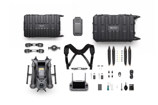
Matrice 400 SP Plus Full Package
Regular price $14,099.00 CADRegular price -
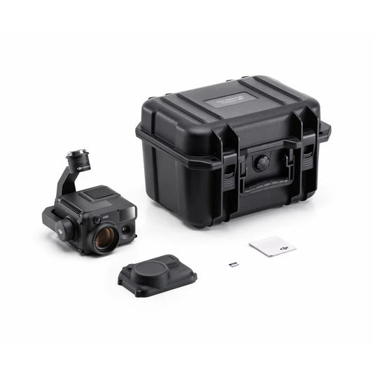
DJI ZENMUSE H30T
Regular price From $12,810.00 CADRegular price -
DJI Zenmuse L3
Regular price $20,225.00 CADRegular price -
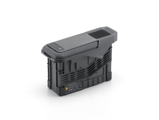
TB100 Intelligent Flight Battery
Regular price $1,945.00 CADRegular price